 November 27, 2008…a thanks giving morning. We awake to clear and deep blue skies, a brilliant warming sun, the thunderous sounds of waves breaking upon our shoreline and the cry of a distant Red Shoulder Hawk soaring over our nearby hillside. We have reflected back upon all our episodes during the last two years…and cannot find an end to the multitude of things we are thankful for…starting and ending with the love, concern and support of our family and friends. The experience of full-time motorhome living, which is approaching our two-year anniversary, has drawn us to the wonder of so many serene and beautiful “rest” stops, introduced us to the most unique, friendly, courageous and loving souls, and witnessed the strength of a perfect partnership as it defied that perfect storm...
"Even with a broken wing...she still carries a dream and she never stopped flying..."
 We are now back to where it all began…Cambria…Pines By The Sea. And in a short time we will be back living in a home with a foundation of concrete, five times more living space, a bathtub and of course... a toilet with unlimited holding power. We are looking forward to this “temporary” change…but will miss the wonder, comfort, companionship and protection of our beautiful coach.
 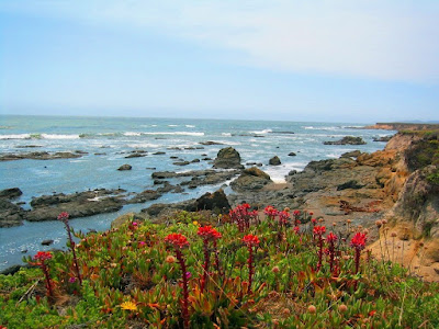 We will not be idle though...for there will be no lack of adventures, no moments without dreams and always creative plans for tomorrow. We forsee ourselves staying very fluid and simplistic, maintaining a healthy lifestyle, continuing to seek out nature’s treasures and ensuring that no byte of camera memory is left un-used.
And we extend our sincere gratitude to those of you who have made a positive impact in our lives, who offered without conditions, kindness and wisdom, nourished us with your genuine friendship, shared many a glass of wine (there sure are bunch of “ya”), made us laugh, cry and inspired us with your life’s adventure …reinforcing that we must never stop making ours. To you all, which there are too many to name, a heartfelt invitation…“mi casa es tu casa”…the Blanics will always welcome you to our beloved Central Coast.


 And speaking of fuel...you would never guess that there is a crisis on gas pricing after seeing all the rigs in this park. Every space in Winchester Bay is occupied. Row after row of parking sites feature high end diesel pushers or behemoth fifth wheels being pulled by monster trucks...a
 Although the most difficult chores on our short list was to watch the tide go in and out each day and crack up some fresh crab...we did manage to squeeze in some time to explore some new locales. A few miles north of us were many magical trailheads, easy to strenuous hikes, into the thick coastline forests.
 We now go from oceanfront to riverfront and a short 3 hour drive west to the middle fork of the Willamette River located in the Willamette National Forest. After a few hikes, a few beers and many outdoor grills there should be a few more highlights for our next entry...
  Oregon and Coos Bay welcomed us with a full moon, high wind, patchy cloud cover and brisk temperatures in the low 60's...but still a very far cry from the winter days we experienced as we departed the state in March. But we did find a scenic site to park our coach, overlooking the bay, at The Mill Casino RV Resort.
 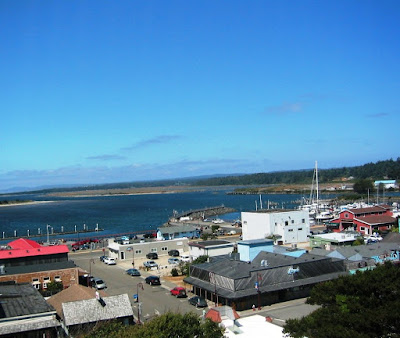 "Old Town" on the waterfront is an offering of cutesy art & crafts, tourista boutiques and small dining establishments.
 Across the river is the picturesque Coquille River Lighthouse built in 1896. We both agreed it would be a lot of fun to be a volunteer in the lighthouse gift shop...when weather is more temperate. Maybe in the future.
 Pristine white sand beaches, dotted with rock "castles and turrets" that stretch endlessly in each direction...showing no signs of any human presence...not even foot prints.
 A short drive from Coos Bay is the small coastal fishing village of Charleston, located just inside the entrance of the bay. Have a taste for fresh dungeness crab, fish or clams?...then a visit to the Charleston Marina is a must. We found fresh albacore tuna for $2.50lb. and live crabs for $6.50lb., a bargain for these Californios to say the least.
 Just a short 4 mile drive south of Charleston was a treasure of a find, and mind you, only if you possessed a "relentless passion to find every one of nature's theme parks" would you find this place...the South Slough National Estuarine Research Reserve. A beautiful interpretive center welcomes you to the reserve and will provide you all the necessary information needed for your exploration. Miles of hiking trails will transport you through a multitude of habitats...forests, salt marshes, mudflats and channels.
 Today, fishing, timber and tourism provide the economic backbone of this charming coastal town. The harbor was picturesque…deep green, mirror like…almost surreal except for the occasional departure of the harbor taxi.


 Situated in the heart of California’s coast redwood country, Trinidad borders the 640 acre Patrick’s Point State Park. Along with the night and morning fog, blankets of redwood, spruce, hemlock, fir, pine and red alder create the perfect habitat for non-stop orgies, feeding frenzies or just an afternoon of laying around for the elusive Banana slug. Sharing these forests and calling it home are the “usual suspects”…i.e. deer, black bear, mountain lion, bobcat, coyote, fox, raccoon, skunk rabbit, squirrels, etc.
  We took advantage of the miles of hiking trails that crisscross the park…a wonderful walk through old growth redwoods and Sitka trees, carpets of wildflowers (heaven for Jackie K. and John H.) and endless meadows of ferns. Some parts of the trail were so dense with vegetation that unless you were a “White Rabbit”, it would be impossible to penetrate…thus with walls of vegetation, our hike sometimes resembled a walk through a maze.


